Abandoned Trails Of Acadia national Park is a site dedicated to covering lost and abandoned hiking trails in Acadia. We cover old ghost trails as well as phantom trails, offering visitors to our site more trail listings, more trail details and more maps than any other online site. We regularly update the site and add newly discovered information as it becomes available.
It has been written that the Park Service once had their living quarters located up on Young's Mountain, but on exploring the area I found no such evidence of this. But in later research I learned that the Park Service had a number of one room log cabins, very small, that served as shelters for Rangers to get in out of bad weather should a storm come along. One of those cabins was located on Young's Mountain.
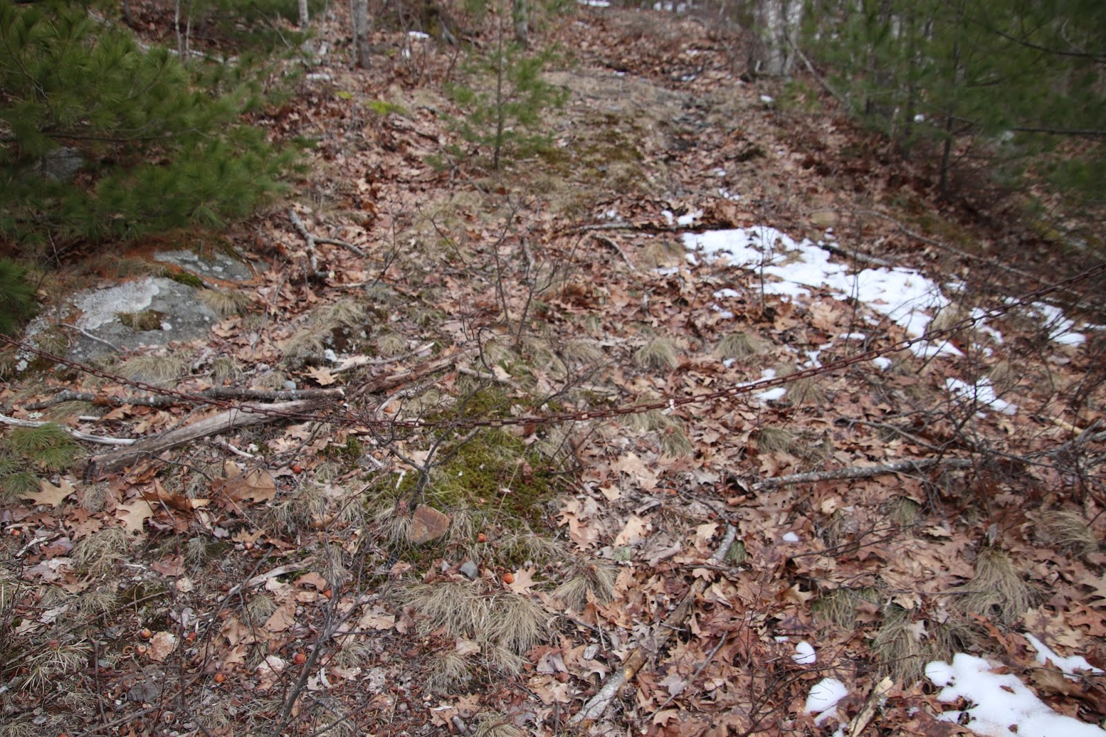
The trail up is not that hard to locate, and is well worn for some stretch, but than as it begins to make its way up the mountain side, vanishes. We were able to make out way up the mountain side with little trouble, and soon got lucky and picked the trail back up again. Common sense tells you in these cases that if you lose the trail, simply head upward for the summit.
YOUNG'S MOUNTAIN TRAIL - Acadia National Park
We did reach the Youngs Mountain Summit, and found a trail marked with rock piles leading down one side of the mountain towards Mcfarland Mountain. I had expected to see this as Mcfarland mountain also has an abandoned trail leading up to its summit. I have read that its trail is in rough shape.
A quick look around the summit and we located another trail, this one well worn, heading in the direction of Lake wood, something we did not expect to find. The day was getting late, so we decided to hurry down this trail as far as we could, hoping to make the Lake wood area, or even Fawn Pond. We had flashlights, so gave it a shot.
YOUNG'S MOUNTAIN - Acadia National Park
We got some ways down the back side of Youngs Mountain and Lake Wood was getting much closer, but so was the close of daylight, and having never been in that area before we decided to turn around and make our way back up Youngs Mountain. As we approached the summit we did so by flashlight. We were not alone, half way down one side of the mountain side we spotted a couple flashlights of someone making their way down, as we were about to do. We knew the direction of the Breakneck Ponds and moved downward in that direction. By the time we reached the Breakneck Road those other flashlights were nowhere in sight.
This is just a guess, but I would say had we been able to follow that trail toward Lake Wood, it most likely would of connected to the Fawn Pond trail, perhaps closer to Fawn Pond than Lake Wood. I checked a few old maps and could not find that trail on them, so it may well be a true Phantom trail, where some one blazed their own trail up the mountain. It was well worn, so clearly a number of people hike it regularly.
OLD CAR FENDER
So to locate the Youngs Mountain Trail, you need to be at Breakneck Ponds, at the place where the Breakneck road crosses between the two bodies of water. Once across, the road enters the woods and turns a sharp left, at that point you want to take a right and follow a worn path. I have had several people contact me and let me know either rangers or Ridge Runners have been in this area and placed branches and a tree across the start of the path, making it harder to spot.
As I recall, there was a less worn path that ran to the right and ended up at a dead end. We also saw several old rusting car parts along the trail, old fenders, a car hood, and such.
The main trail went on for a ways before coming to an end as the trail started up the Mountain side.
The summit is marked by a rock pile and the Lake Wood trail we found begins there.
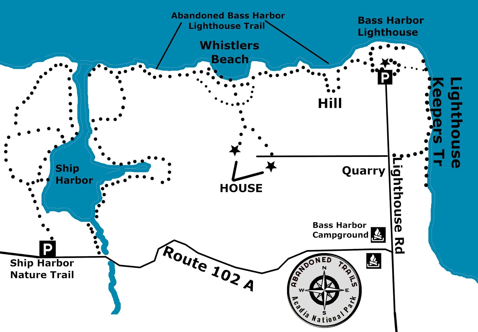
I stumbled upon the Bass Harbor Lighthouse Path one day, it may of been a hand drawn map, in a book at the College of the Atlantic, it showed a path running from the Bass Harbor Lighthouse to the mouth of Ship Harbor, on the side where there is no official path. Not far away the path continued on, for the most part following the edge of the harbor, but running through sections of woods in a few places. The trail crossed one brook, then a second, following that brook a short ways before making its way to the current Ship Harbor Nature Trail. It took me some time to find all the sections of the trail, but I will begin at the Bass Harbor Parking lot.
BASS HARBOR LIGHTHOUSE - BASS HARBOR MAINE - Acadia National Park
At the parking lot there are two trails, many visitors to the lighthouse either see one or the other, few see both because they begin at either end of the parking lot. The one to the far right leads down a paved path, with a wooden fence along it. Half way along that path is a small gate with a small field, on the other end of the field, in the woods is one access point of the Lighthouse Keepers Trail, see that blog for more on that path.
To the far left of the parking lot is a restroom, with a dirt path running past the restroom that turns hard right and leads to a long steep wooden stairway which leads to a path below the lighthouse, close to the waters edge. From there you can look up and see the lighthouse perched on the edge of a cliff, it makes for a great photo.
About six feet before the wooden steps there is a well worn path just inside the woods, that is the start of the Bass Harbor Lighthouse Trail, and the beginning of the trail is usually has tree branches tossed over it to conceal it, this is an abandoned trail and not marked or maintained.
95% of this trail keeps the ocean in sight from the trail, and the trail is fairly easy to follow. It makes its way to a small hill, on the other side of the hill the path continues along the ocean, with many places where you can step out onto cliffs and get spectacular photos of the ocean and passing vessels. The path continues onward until you reach a very high cliff with a stone beach below, this beach is known as Whistlers Beach. The beach got its name because a local man constructed his own private path from his back door to the beach. Maybe it is because that activity in itself is illegal, or he just wanted people to scatter as he walked his private path, but he would whistle as he walked his path to the beach, then whistle as he left and made his way back home, thus his name, Whistler.
Whistlers Path is at the very top of that high cliff, but others who live on a dirt road outside the park also travel along Whistlers path, some walking their dogs or taking their kids to the beach. People in Bass Harbor also walk, some with dogs or kids, along the Bass Harbor Trail from the Lighthouse end, the path is well known among the locals.
From the beach the path continues on toward the mouth of Ship Harbor, passing along an area where nice pieces of drift wood often washes up along the shore, in one area sections of an enitre dock lie in ruins, ripped from where it was during a storm and tossed up along the side of the Lighthouse Trail. The trail finally comes out at the mouth of Ship Harbor, on the opposite side and directly across from the Ship Harbor Nature Trail. I would often set here on the rocks and visitors on the other side would look across and wonder how I got to where I was. Moving back the way you came, but not too far, there is a hidden section of the trail that runs through a section of woods before once again coming out near the shore of Ship Harbor. It makes its way along the edge until it crosses a brook, from here you have two choices, simply follow the open edge of the woods to the second brook, or look for the path just inside the trees, it stays within the tree line but within view of the harbor and leads to the second brook. At the second broon follow the side of the brook to route 102 A, go right and the Ship Harbor Nature Trail is right there around the corner.
BASS HARBOR LIGHTHOUSE - ACADIA NATIONAL PARK
This is an abandoned trail which over the years has had a lot of Trail Phantom activity, thus it should be obvious it is paroled by Ridge Runners and MONITORED by the Park Service. Always assume the woods have eyes...
I can't find anyplace where this trail is labeled, and when I first listed it some contacted me and said this was actually the Orange and Black Trail, which if you look at old maps, the trail appears to be a quick access route to the Orange and Black trail, used for perhaps a short cut for workers who were constructing the Orange and Black trail or working on the nearby Precipice and Great Cave Loop. . I simply have called this the Lost Rudolph Brunnow Trail. Take a moment and study the old map below, I have outlined this lost trail in red. Notice the white Path is a separate path that crosses this path we found. Now once again study the old map and notice that this lost path, along with the Great Cave Loop, are both marked lighter than the other trails on the map. I don't know why these two paths are marked lighter, but they are.
So we have now come up with two much easier ways to locate the area this lost trail is in. Begin at the Orange and Black trail post located before you get to the precipice parking area. There is a storm drain next to the trail marker, that is storm drain one. Now walk in the same direction as the traffic until you reach storm drain four, that is where you enter the woods, to the left side of the storm drain. A short ways away is a very huge boulder with a split across it.
The second way to locate the area of the lost path is by GPS, storm drain four is located at
N 44 21.172 W 068 11.277
base of the stone gully is located at
N 44 21.183 W 068 11.306
When you look up toward the top of the gully, you will see a line of white birch, the stone steps run along the back side of those white birch before turning the corner along larger steps.
One of many storm drains along side of the Park Loop Road
The stone gully is located straight in and slightly to the right, it is the only gully in that area. So why is the stone steps higher up easy to see once your at the top of the gully, steps to the right, and the path up the gully is not so easy to see? So once we located this lighter marked trail, finding out how this section of trail became abandoned took a bit longer to uncover, but thanks to old newspaper articles, in time we did just that. As it turns out, the Orange and Black Trail has had a long history of being plagued by rock slides, and as we discovered in one old article, every few years crews have to return to the trail and rebuilt sections of it, which has resulted in several legs of the trail being abandoned, this section we uncovered we now believe is one of those abandoned sections of trail. Another old article written many years later stated rock slides continue to plaque the Orange and Black trail.
Than in 2006 the Big One struck, an earthquake that sent people hurrying out of downtown shops, with a magnitude of 4.2. Now that may seem a walk in the park to people who live in places prone to earthquakes, but here on the island, that was huge. I was walking down Cottage Street when it hit and just knew what it was. It was one or two days later when me and my oldest son were free climbing up the side of Cadillac Mountain when a good size after shook hit, we turned around and called it a day. . The epicenter of the earthquake was located in the Atlantic Ocean just off Schooner Head, on the eastern side of the park. Damage appeared to be limited to rocks falling on the Park Loop Road, which re-opened on Tuesday afternoon after a brief closure, and some park trails (see Temporary Closures for a list of closed trails).
Trails that were shut down due to earthquake damage at the time included most of the trails found on Champlain Mountain, including the precipice, the Orange and Black Trail and the Bear Brook Trail (on some maps called the Champlain North Ridge Trail).
From road go straight in short ways until you reach rocky gully slightly to the right running upward.
Once you reach the top of the gully look to your right and you will see stone steps. Unlike the much larger stone steps leading up Dorr Mountain, these are smaller stone steps which run between the mountain side and a row of white birch. As the steps approach a corner, the stone steps become larger. The path turns left higher up, and cuts back in the direction you came from but at a higher level. The trail runs straight ahead before coming to thick brush, here the trail turned upward, and just a short ways ahead is the official Orange and black trail. We believe there was once stone steps leading to the official path ahead and the Park Service removed them so people hiking the Orange and Black path would not see the other path.
Rocky Gully - at top, look right for stone steps
To locate this trail, drive, bike, hike or take the free Island Explorer bus to the Precipice parking lot. If using the bus, make certain you let the driver know you want to get off at the Precipice parking lot. He may tell you the trail there is closed due to endangered Falcons nesting along the Precipice, just tell you to let you off there.
Now walk along the Park Loop Road, going against the traffic, until you reach the Orange and Black Trail Head and follow the directions I have given earlier in this post.
UPDATE
From the moment I discovered this long lost trail, my gut instincts told me this trail was built not as a hiking trail, but as a supply trail as a quick and easy access to both the Orange and black trail and the nearby Precipice Trail, and a piece I came across bears this out. In the book Trails Of History I came across the following; "As the Orange and Black Path descended below the cliff over which Brunnow hoped to scale, he built a second connecting path across the freshwater meadow (todays Bliss Field) . A rock staircase, currently abandoned, leads up to the Orange and Black Path. This short trail provided quicker access to the business at hand, the building of the Precipice Trail."
What is described there is exactly what my youngest son located, and what we came to label the Lost Rudolph Brunnow trail. This is a short direct trail to the Orange and Black Trail, with a stone stair case, as described. The trail also cuts about three froths of the hiking time off of the official Orange and black Trail, making access to the upper area of the Precipice Trail muck quicker. This also explains why on some old maps you actually see this trail, unmarked and outlined lighter than the other trails, it was never meant to be a hiking trail, but a trail used by the work crew who used it to carry on their work on the upper section of the Precipice Trail.
Rock gully as seen from the stone steps
Strom Drain One
This large boulder is a short ways from storm drain number four where you enter the woods..
Standing by the rock gully looking toward the Park Loop Road.
Stone gully leading upward. At top of gully look right and path and stone steps are there.
Brewer Mountain is just one site that the Bar Harbor water company has abandoned over the years. There are two more sites it abandoned on the sides of Great Hill, one being the Water Tower of great Hill. It lays at rest like a sleeping giant in the shadow of trees.
Old Road Leading Through Woods to Water Tower
Many years ago the narrow dirt road leading up to the tower was clear and easy to see, but not so today. Wild brush has been allowed, or even encouraged, to grow up in the center of the dirt road, and the rusting chain that stretches across the road is hard to see through the brush.
But iff you know where to look, this sleeping giant can be all yours for a day.
From the Eagle Lake road, Route 233, drive until you come to the Duck Brook road on your right, just before Eagle lake. Drive down the Duck Brook Bridge Road until you come to the end at Duck Brook Bridge and the carriage roads. Almost across from where cars park is a wide open clearing on the side of Great hill with a road leading up to the current Bar Harbor water system. And than there's that small building on the other side of the roadway. Almost across from that building, and not far from the road leading up to the current water system, look for an old rusting chain the blocks the start of the
Great Hill water Tower - Acadia National Park
water Tower road. Once you cross the chain and start up the road, the brush ends and the road can be much easier seen. You don't have very far to go before you come up to the huge water tower.
Today it sets abandoned, but it is a prize for those who are into exploration.
GREAT HILL WATER TOWER
Acadia National Park
The map above is much clearer as to how to locate the water tower, what I did was stand in front of the two telephone poles across the road from the building on the Duck Brook Road, across from the pole on the right I walked off forty steps, toe to heel and was right in front of the start of the old dirt road. The road moves at a right angle as shown on the map before turning, the entire road forming an S shape. Right now, in early spring, we can easily see the rusted chain blocking off the road, but it is surrounded by thick brush and once the leaves come out you will not be able to see the chain or make out the road until you walk in a short ways, when the road becomes worn and free of brush. As it turned out at exactly forty steps there was also a short line spray painted on the edge of the road, I guess that is how the Park Service remembers where the old road begins.
Old chain blocks old road
It is worth noting, I have never really looked for the section of chain higher up the tree above, that section may be able to be seen from the road, but maybe not, as it is up a banking and when the brush have leaves I am pretty certain it can't be seen, but I will check that out when the leaves are out.
Here you can see how low the chain hangs
Photo above is a view along the road, looking back toward Duck Brook road, you can see the water company building in background. As you can see from this photo, once you get beyond the brush by the roadside, the old road is very well defined and easy to follow right up to the tower.
Above is the old road just before the final turn when the tower comes into view. There are a few small branches here and there, a couple pot holes (I stepped into one) but over all the road is not a long or hard walk.
GPS for start of over grown dirt road leading to water tower - N 44 23.41`9
W 068 14.143
f you have ever wondered just how Great Hull got its name, well, you would have to hike up to its summit to understand how it came to be named a Great Hill. Before you have even begun your hike, one quick look back behind you and you will have a view of the surrounding mountains that you can only get from Great Hill, and the views only get better the higher you go. In my opinion some of the best views of Acadia national Park can be found from the sides of this hill, and even it you miss a view here and there on the way up, the trip down with be like an added bonus.
Mountains of Acadia National Park viewed from Great Hill
Kebo Mountain is drafted by its bigger brother Cadillac, with Dorr and Champlain mountains rising in the distance, all lined up perfectly for a great photo with the ocean as a backdrop. You will not find this view on any other mountain summit other than Great Hill. And when hiking to the first summit, you can look across to Great Hill's twin summit - there once was a couple trails that begun at the first summit and led to the second one, but they are now pretty much ghost trails, with small sections of those trails showing up now and than.
I like to think Great Hill got its name because many years ago it as a cross roads, with a number of trails connecting to Great Hill, and the Trails of Great Hill connecting to Hulls Cove and Bar Harbor
. The Gurnee Trail was connected to the Fern Trail, from Duck Brook Bridge the Fern trail got you to the Great Hill Trails, like the Water Pipe Trail, and as the Fern trail followed one side of Great Hill, it continued on down to near the intersection of the Cleffstone Road and West Street Ext.. Trails also ran up to both summits, with one running down the other side toward Duck Brook Bridge, and another running down to join up with the Bracken Trail., which in effect connected hikers to the Breakneck Road, Mcfarland and Young's Mountains, and the Fawn Pond Trails. Even the trail around Witch Hole Pond was connected to these trails. And from the Bracken Trail you connected to the Gorge Trail and the rest of the trails in Acadia National Park.
Bar Harbor viewed from Great Hill - Acadia National Park
But following the Great Fire, the Park service decided to abandoned all trails on this side of the park - if you wanted to hike on this side, you would have to do so by means of the Carriage Roads, which as any serious hiker knows, can not compare to hiking an actual trail.
So how do you locate the main trail to the summit of Great Hill? Here are two quick ways of getting to it so you won't miss it.
1. From downtown Bar Harbor, drive down to the bottom of Main street, the ocean end, turn left onto West Street and drive to the end where you come to an intersection. Route 3 - Eden street runs left and right, continue straight ahead up West street ext.. Continue until you come to a stop sign and the Park Loop Road. Turn left and drive past the first pull over on your left, stopping at the second pull over. You are now at where you need to be.
Great Hill Summit - Acadia National Park
2. From Bar Harbor, turn onto Mount Desert street by the Village Green. Continue along Mount Desert Street, driving through an intersection with lights on up the Eagle Lake Road, or route 233. As you approach the large arched stone bridge, turn into the park. At the Park Loop Road just ahead, turn right, go round a curve and pull into the pull over.
So you have the map, but I will roughly go over the layout of the trail. Directly across from the pull over is a section of ledge, you need to go to the far left of the ledge, by the tree's, and there you will see a worn path leading up to the top of the ledge - often times pesky Ridge Runners will toss branches or limbs across the start of the trail, either kick them aside to prevent you from tripping, or step over or around them.
Just as soon as you reach the top, stop and turn toward the hill, with your back toward the road, and you will see a small opening in the tree's, walk toward it and you will see a section of worn trail which takes you to the first section of open granite.
Get up onto that open granite and walk across it, moving upward, and just ahead you will come to another worn section of trail, which quickly leads to more open granite. Continue tomove upward and just ahead is a long stretch of worn trail which will end at another section of open granite with a very huge boulder at rest a short ways off the trail.
Great Hill Summit Trail - Acadia National Park
View From Side of Great Hill - Acadia National Park
It's that area where the boulder is where you want to be. Now head toward the woods, to the left, and look for a narrow well worn path, that path will lead you to the summit of Great Hill.
When my kids were younger we would come up here just before dusk, and once night settled in look up at the sky and watch for shooting stars. Sometimes we would just set on a large rock and watch as planes in the distance landed and took off from the Bar Harbor Airport. Locals simply refer to this trail as the Great Hill Summit Trail.
But the summit trail was only one of the official trails on Great Hill in Acadia national Park. Another lost trail began at the corner of Cleffstone Road and West Street extension and made its way to the same summit. A trail known as the Fern Trail ran pretty much along the side of the duck Brook road, located just inside the woods and passing through long open areas with ferns. Another trail began further along the duck Brook road and passed straight up the hill, passing between both peaks and down the other side toward the park Loop road. Another trail ran from the Fern Trail all along one side of Great Hill, down past the area of Duck Brook Bridge, before connecting to the Bracken Trail. The Bracken Trail ran from the Duck Brook Road to the Park Loop Road. And half way along the Bracken Path another trail ran up that side of Great Hill to its other summit.
I would be the first to agree that all told, that is a lot of trails for one small area, but Great Hill in reality is a pretty large area, just try walking around the entire hill some day and see how large the area is. The Park Service says all the trails were abandoned on Great hill because of the great fire, which they say left the soil on the hill fragile. Yet nearby carriage roads were not abandoned because of the fire.. Simply put, many locals feel the Park Service simply did not want hiking trails in that section of the park and used the fire as an excuse to abandoned all the trails in the area, and this includes other trails like the Fawn Pond Trail, the Gurnee Trail, and others.
Abandoned Trails Of Acadia National Park
Guide Mape
GREAT HILL GPS NUMBERS
Park Loop Road Pull Over
Latitude - 44 - 23' 3" N
Longitude - 68 - 13' 47" W
Start Of Path
Latitude 44 - 23' 3"N
Longitude 68 13' 48"W
Open Granite
Latitude 44 23' 5"N
Longitude 68 13' 49"W
Worn Path At Woods
Latitude 44 23' 7"N
Longitude 68 13' 51"W
Great Hill Summit
Latitude 44 23' 3"N
Longitude 68 13' 47"W
The Stone Tower of Eagle Lake is part of the remains of the old Bar Harbor Water Company, the tower itself being a standpipe. The tower itself is constructed entirely of large flat field stones stacked up on top of each other, forming a tower. While you can enter the tower, the inside is not large at all and looking up you get the same feeling as if you were in a well looking upward.
Off in the woods to the right, before you reach the Stone Tower, are a couple of enormous foundations which were once part of the Bar Harbor Water Company sand filtering system, in one far corner of one of the foundations you can still find a pipe entering the foundation from nearby Duck Brook.
THE STONE TOWER - Acadia National Park
Even though the structure is actually at the base of Brewer Mountain, it is a short walk from the Eagle Lake boat landing and very easy to locate, see the directions below.
1. Approach one is the easiest by far, drive along the Eagle Lake Road - route 233, from Bar Harbor and watch for a narrow paved road just before the lake on the right, with the DUCK BROOK street sign, park at the corner. Walk down the Eagle Lake Road, in the direction of the lake on the right hand side of the road, you want to cross that small bridge, and just past the bridge you will see an old dirt road entering the woods, follow that road until you come to the Stone Tower in a small field - this is all on Park Property.
OLD ROAD LEADING TO STONE TOWER
2. From the Eagle Lake boat Landing, take the carriage road to the left, follow it a short ways where you will come to a intersection just before a wooden bridge. Go left, this will take you to the Eagle Lake road, the old dirt road will be across the roadway, to the left of the small bridge along the Eagle Lake Road.
Just a little update, today we returned back to the old Stone tower and this time around we followed the large water pipe leading from in front of the stone tower through the woods to the fast moving waters of Duck Brook. Just before the brook we found an interesting find, see photo.
underground tank
From that point we decided to follow the brook for a ways, which ended up being a good choice, as you will see. We took video and photos of the brook as we went, but soon had to turn back and retrace our way back to the stone tower. I remembered an old road behind the tower, and it is well hidden behind some pines. We followed that road, which stays pretty close to the waters of Duck Brook, until we came to out next big find. Here we came upon a large water pipe line that suddenly swung out from the side of the old road and crossed the brook, as you can see from the photos, it was a pretty amazing find.
DUCK BROOK - ACADIA NATIONAL PARK
Just beyond this, the road ended at a swamp, so we turned back around and headed back past the stone tower and out toward route 233 (The Eagle Lake Road). Just before the main road we decided to get a few more photos of the huge foundations that were once part of a sand filtering system. It seems every time I visit this area I come away with another new discovery. Oh, and we made a huge blunder, we forgot to bring along a can of deet and the deadly Maine black flies lived up to their reputation, our arms, necks and foreheads were covered with black flies.
part of the sand filtering system
part of the sand filtering foundation
THE STONE TOWER - EAGLE LAKE - ACADIA NATIONAL PARK
THE STONE TOWER GPS NUMBERS
pull-over at corner of Duck Brook Rd.
latitude 44 22'39"N
longitude 68 14' 41"W
dirt road to tower begins
latitude 44 22' 39"N
longitude 68 14' 46"W
The Stone Tower
latitude 44 22' 45"N
longitude 68 14' 43"W
Other than a name on a map, there doesn't appear at first glance to be much going on at Brewer mountain. However, if one takes a closer look, at least at one time or another there was a lot going on there. Brewer Mountain is where I first stumbled upon the Stone tower. Two huge foundations at its base is what remains of a huge sand filtering system run by the Bar Harbor water company. And an old dirt road from behind the Stone Tower once ran all the way to the area of Duck Brook Bridge.
Much of this can be easily found today, and along that old dirt road with fallen trees here and there blocking it is the very fast waters of Duck Brook.
But there are secret areas on Brewer Mountain one can only find through exploration of the mountain sides. There are a few old house foundations hidden in the woods, and here and there one comes across old rusting car fenders, bumpers, and hoods. There are also a few old dumps with old bottles, rusting cans, shoe souls and such.
Two of the more amazing finds I came across are two old granite mining sites, one is located lower on the mountain side toward Eagle Lake end, the other up closer to the top of the mountain. I am pretty certain there are still other secret areas on Brewer Mountain even I have yet to discover, which is why it is one of my favorite mountains to explore.