 |
| GREAT HILL RESERVOIR Acadia National Park |
GPS TO GREAT HILL WATER RESERVOIR
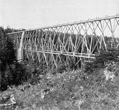
Stone Arched Bridge on Duck Brook Road
44 23' 27" N
68 13' 45" W
AT RESERVOIR ON HILLSIDE OVERLOOKING ROAD
44 23' 28" N
68 13' 48" W
Once I did become aware that it was one of three reservoir's built by the Bar Harbor Water company, I than began to do some research and came upon a document titled, "The History of the Bar Harbor Water Company." Up to that point I had been studying old maps of the island for some years, and was fascinated when I read that no one knew where the location of Scott's Hill was, the site of a second reservoir - which surprised me, because i was pretty certain I knew exactly where Scott's Hill was located. You see, one of the old maps I liked to study had the names of land owners on it, and I knew from that map that a Mrs. Scott owned land on top of what many call School House Hill today, in fact she owned a large piece of land there.
 |
| SCOTT'S HILL MAP (Schoolhouse Hill) Bar Harbor Maine |
And if you look at a map, the reservoir on the side of Great Hill lines up perfectly with School House Hill, or Scott's Hill. I contacted the local water company by email with my findings and never heard back from anyone...oh well, I simply went back to continuing my research into these reservoir's, and have since made even more discoveries.
 |
| SCOTT'S HILL (Schoolhouse Hill) Bar Harbor, Maine |
In a Bar Harbor Record article on the Bar Harbor Water Company, dated Feb. 9, 1893, it states that Mrs. Scott owns a Cottage on top of Scott's Hill, and goes on to state the elevation of her cottage. It goes on to list other land owners on Scott's Hill and gives their cottage elevations. I went back to that old map with the property owner names listed on it, and sure enough, the property owners in that old newspaper article line up with the property owner names on that old map, so there is no question now of where Scott's Hill was located.

I went back and reread that report of the History of the Bar Harbor Water Company, because I was pretty certain I noticed another mistake in that report. It states that though it is not know what the reservoir on Scott's Hill was constructed of, it is believed it was constructed of stone. This is not correct, at least according to old newspaper articles from the late 1800's which state that the reservoir on Scott's Hill was constructed of wood. I know from that report that people from the Water Company did a search for that lost reservoir and could not locate it, however if it was constructed of wood, one would not find evidence of it all these years later, even if you were searching on the right hill.
 |
| POST CARD SHOWING VIEW FROM SCOTT'S HILL Bar Harbor, Maine |
A third and final reservoir was constructed on a place named Cunningham Hill, I did research on that and learned that Cunningham Hill was also known as North Ridge?? I have not had any luck tracking this third and largest reservoir down, but the Water Company report states the third reservoir had to be build because the one on Scott's Hill did not furnish enough water pressure. Not long after the third reservoir was constructed the entire reservoir system was abandoned in favor of pipes.
 |
| PHOTO SHOWING VIEW FROM SCOTT'S HILL Bar Harbor, Maine. |
 |
| GREAT HILL WATER RESERVOIR Acadia National Park |
 |
| VIEW OF DUCK BROOK ROAD AND BRIDGE FROM RESERVOIR Acadia National Park |
I gave the GPS for the Great Hill Water Reservoir, and I will put up a simple map soon, but for now I will say even if its your first time to Acadia National Park, you can easily locate this abandoned Reservoir.
From bottom of Main Street in Bar Harbor by the town pier, follow West Street until you come to intersection with Eden Street - route 3. Continue straight ahead and up over the hill until you come to signs of entering the park. Just ahead, on the right, is the Duck Brook Road - the road is blocked to automobiles, but you will not need a car or bike. Park there and walk a short ways to the Stone Bridge, just after passing under that bridge, up on the hillside is the abandoned Water Reservoir, worn paths there lead right up to it, the path closest to the side of the bridge simply takes you to the Park Loop Road above.
 |
| BAR HARBOR WATER COMPANY FLUME |
 |
| GREAT HILL RESERVOIR MAP Acadia National Park |
No comments:
Post a Comment
Note: Only a member of this blog may post a comment.