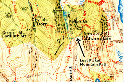
I had read somewhere in the past that the person who owned the land on Picket Mountain and had their own path up the mountain, but over the years that path fell in rough shape. This map shows other nearby abandoned trails as well, the Meadow Path which ran from the Sieur de Monts Spring area over towards the Beaver Pond and connected to the also abandoned Black and White Trail, and the White Path, which I had read was pretty much destroyed when years later the Park Loop Road was build over it.
This lost Picket Mountain (now named Huguenot Head) path is not an easy path to locate, this is due to the fact that much of the path crosses over granite and up through a boulder field, but after spending a couple hours at it we did locate the path,, which is marked today by rock piles along much of the route. Interestingly, I came across this piece in an old paper, stating that this trail was in fact a memorial path;
NEW PICKET MOUNTAIN PATH
Bar Harbor Record
Sept. 16, 1914
I have also to announce that Mrs. C. Morton Smith has just made an equally generous offer to present a memorial path in memory of her late husband, and that she has decided, on the recommendation of the committee, to have it on the western side of Picket Mountain, where it will lead from the gorge Road opposite to the entrance of the Kane Path to the summit of the mountain slope from which some very fine views of the ocean to the north and south are obtained.
A clue as to the route the path took is in the map itself, it followed the path the brook took.
You can see on the map that the Dorr Ladder Trail comes out to the Otter Creek Road (route 3), the Lost Picket Mountain Path begins just up the road, and has a clear landmark as to the start of the path. As your leaving Bar Harbor and pass by the Tarn, look for a small paved pull over on the left hand side of the road, the brook and start of the path are close to that pull over, just inside the woods.
We could not find the actual start of the path, so we hiked up through the woods along the brook and once we got up aways, we began to criss-cross the area until we located the first rock pile, from there one rock pile pretty much led to the next until we exited the woods and came out at a boulder field which appeared to run right straight up to the now Beachcroft Path, though back in the day this path would of gone right up to the summit of Picket Mountain, since the Beachcroft Path had not yet been built. Dusk was coming on so we never got to follow it all the way, but we did take some photos along the way.
 |
| OLD MAP OF HUGUENOT HEAD (Picket Mountain) Champlain Mountain - Acadia National Park |
 |
| OLD HUGUENOT HEAD PATH Champlain Mountain - Acadia National Park |
 |
| OLD HUGUENOT HEAD PATH Champlain Mountain - Acadia National Park |
 |
| ABANDONED HUGUENOT HEAD PATH Champlain Mountain, Acadia National park |
 |
| ABANDONED HUGUENOT HEAD PATH Champlain Mountain - Acadia National Park |
No comments:
Post a Comment
Note: Only a member of this blog may post a comment.