Abandoned Trails Of Acadia national Park is a site dedicated to covering lost and abandoned hiking trails in Acadia. We cover old ghost trails as well as phantom trails, offering visitors to our site more trail listings, more trail details and more maps than any other online site. We regularly update the site and add newly discovered information as it becomes available.
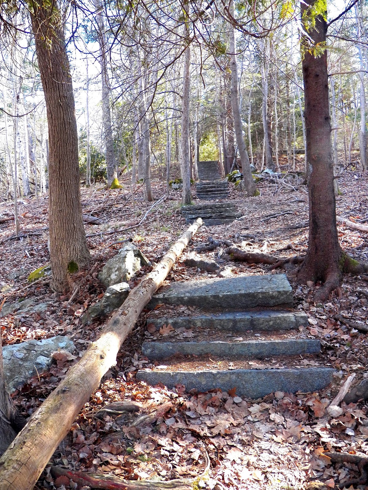
The Hanging Steps is not a trail, the real name is the Orange and Black Trail, the half of the official trail the Park Service chose to abandoned. The Hanging Steps was a Main attraction along the Orange and Black trail. Rudolph Brunnow designed both the Orange and Black Trail as well as the once popular Hanging steps. The most amazing feature of the Hanging steps is that they appear to "hang in mid air," with drop offs to either side of the steps. Brunnow achieved this feat by way of using hidden iron bars to hold the huge granite steps in place. They got their name, it is said, when a park ranger came to the site to view the steps for the first time and exclaimed, "They appear to hang in mid air," and from that day forward they were referred to as the Hanging steps.
CHAMPLAIN MOUNTAIN - HANGING STEPS - ACADIA NATIONAL PARK
Abandoned Trails of Acadia - The Hanging Steps
I have been asked a number of times, does the trail end at the Hanging steps - no, it continues on up to some cliffs, than makes its way through a section of woods before coming out at open granite. From there you only have one way to go, follow the open granite downward until it joins the lower section of the Precipice Trail at the base of the Turn around, a huge boulder in the trail with a few iron runs placed in a way to make it hard for inexperienced climbers to get past. With just a little bit of looking you can find where the trail continues at the top of the Hanging steps.
THE HANGING STEPS - Orange and Black Trail - Acadia National Park
Above is perhaps the best photo of the Hanging Steps I have seen to date, and the photo was taken by David Schortmann. I want to thank him once more for his contributions to our sites.
SIGN IN LEDGER - ROCK CLIMBERS TRAIL
Within a minute or so after starting down the unmarked trail you come to this huge boulder with a sign in ledger. The ledger is there for the rock climbers in case some one is reported missing, that might of had an accident while rock climbing. Rangers can take a quick glance at the ledger and know who went up by rope and who came down and when.
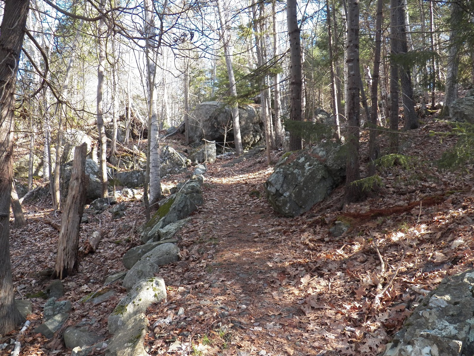
ROCK CLIMBERS TRAIL - GRANITE WALL STRAIGHT AHEAD
So as you can see, the first half of the Orange and black trail, the abandoned half, arrives at the official Precipice Trail, than followed that trail upwards a ways to the area of the boulder field. Around that point, the Great Cave trail went left, and the official half of the Orange and Black trail goes right. In the photo above, is the path from the road to the high wall of granite where you turn left, and below is the wall of granite with a right turn ahead, which leads up to a very twisted tree you need to pass under, or over.
AT GRANITE WALL - VIEW LOOKING LEFT
From the map, you can see a path just beyond the Precipice parking area, an unmarked but well worn path that enters the woods. This path today is mainly used by rock climbers who go there to practice their climbing skills. You will come to a towering wall of sheer granite, the rock climbers use gear to climb that wall, turn left and follow the path to the corner where it turns right, goes upward and under a very crocked tree. Continue ahead until the path takes a right turn and continues upward, here you will begin to see stone steps. From here the trail is easy to follow until you reach the top of the Hanging Steps.
CONTINUE TO FOLLOW SIDE OF GRANITE WALL
pass under the twisted white birch
Pass under its twisted branches and look up - that huge impressive boulder seems like its ready to drop right down onto the path where your standing.
IRON RAIL NEAR TOP OF HANGING STEPS - ACADIA NATIONAL PARK
VIEW FROM TOP OF HANGING STEPS - ACADIA NATIONAL PARK
While the abandoned section of the Orange and Black trail is not too hard to follow, we have added extra GPS points for those who might venture beyond the top of the Hanging Steps. There are a couple places where GPS numbers further up might come in handy.
HANGING STEPS
trail begins
latitude 44 20' 50"N
longitude 68 11' 15"W
right turn
latitude 44 20' 49"N
longitude 68 11' 22"W
right turn
latitude 44 20' 50"W
longitude 68 11' 22"W
to woods
latitude 44 20' 50"N
longitude 68 11' 21"W
woods path
latitude 44 20' 51"N
longitude 68 11' 21"W
woods path
latitude 44 20' 52"N
longitude 68 11' 20"W
open granite
latitude 44 20' 53"Nlongitude 68 11' 20"W
open granite
latitude 44 20' 55"N
longitude 68 11' 19"W
Precipice Trail
latitude 44 20' 57"N
longitude 68 11' 19"W
HANGING STEPS TRAIL
HANGING STEPS TRAIL
BEYOND THE HANGING STEPS - TRAIL ENTERS WOODS
WOODS TRAIL BEYOND HANGING STEPS
BEYOND THE HANGING STEPS - TRAIL HEADS TOWARD PRECIPICE TRAIL AND OPEN GRANITE
UPDATE
So with new information on a section of the Hanging Steps end of the Orange and Black Trail (the end now abandoned by the Park Service) we returned to the area in hopes of locating those stone steps we had missed. We did locate them, but it did take a little searching, this section of trail we had missed is a loop that runs through the center of the boulder field, and I would reccomend for most people going the way we outlined on the map will be your shortest and safest route.
Now for the missing section of the trail, once you come to the sheer climbing wall and turn left, than right, you want to approach that old sideways tree blocking the route. About halfway to the twisted tree, to the left, there are two large sections of granite with a narrow passage way between the two large sections of granite, you pass through that narrow spack and continue to follow the path, which is stone and at times you have to stop and search were to go next. Around a corner the path gets really narrow for a short section, granite on one side of you and about a five foot drop on the other. Once past that you come to stone steps and stone stairway, clearly the earthquake some years ago that made a mess out of a number of official trails also made a mess here as well, as it quickly became clear that some sections of stone steps were missing, and in one spot some large boulders had fallen down onto the trail. From here it appeared the trail went off in two directions, one continueing up through the center of the boulder field to a look out spot, and the other moving straight ahead in the direction of the hanging steps, joining up with the smae area we have marked out on the map.
Because this section is hard to locate and not so easy to follow, as I said, the way we have marked out on the map is much easier and safer, but if you are looking for an adventure, than searching out these hidden stairways might be for you.
Abandoned Trails of Acadia National Park - The Book
Compass Harbor is one of the biggest kept secrets in Acadia national Park, and the Park Service wants to keep it that way. The nature trail which runs a loop through Compass Harbor offers the visitor a chance to sight many different species of birds, including a variety of woodpeckers and owls. Deer wander the woods here as does wild turkeys, and on the nearby Dorr Pond one can spot wild birds near the shore as well as wild ducks on the pond.
The National Park Service considers the grounds of Compass Harbor to be of historical significance, mainly because the man considered to be the Father of Acadia national Park, George B. Dorr, had his summer estate located here, for which the remains of lie on a hilltop in the woods with the main trail leading you to them. Without the money and tireless work of Mr. Dorr, there most likely would not be National park in Maine.
Mr Dorr was a man of great vision, yet in some areas his vision was limited, for he might never of left his estate, Old Farm, and its other buildings to the National Park had he foreseen them tearing them down after his passing.
Supporters of Dorr have tried for many years to get the National Park Service to recolonize him by placing a monument in his honor at Compass harbor, but the Park Service has refused to entertain such requests from the public. All of the buildings Mr. Dorr owned were torn down by the Park Service but one, that being Storm Beach Cottage, a charming older cottage up on a hillside along the Old Farm Road, which runs along one side of Compass Harbor property. It was at Storm Beach Cottage where Mr. Dorr lived out his final years, where from a window he could look out over the land he so loved, and see the lands that made up The Mount Desert Nurseries, a business he owned.
SMALL BEACH AT COMPASS HARBOR - ACADIA NATIONAL PARK
Should you decide to hike even a section of the Schooner head Trail, which begins at the Compass Harbor path, it will lead you to a tiny parking area on the Old Farm Road, where it crosses the road, just a few yardsfurther and to the right is the Dorr Pond, a favorite spot for wild ducks. A little further along the trail and you begin to see pipes sticking out of the ground along the side of the trail, these were once part of the watering system for the Mount Desert Nurseries.
Back at Compass Harbor, in the nearby woods are foundations, one being the foundation of a hot house that was once used by the nursery business. A foundation for a servants quarters is also located in the nearby woods.
An excerpt taken from a newspaper story recently read, "A “cultural landscape assessment” of the former Bar Harbor estate of
George Dorr, a founder of Acadia National Park and its first
superintendent, will be conducted to find and inventory remnants of the
main house, outbuildings, gardens and other significant features."
The newspaper story goes on to say, " The privately funded landscape assessment will help Acadia officials
make decisions about the future management and protection of the
property."
STORM BEACH COTTAGE
OLD FARM ROAD
Compass Harbor - Acadia National Park
On a hot summer afternoon groups of locals can be seen along the Compass Harbor Trail, making their way to one of several swimming spots along the shore of Compass harbor. At one spot along the trail is a long series of stone steps which run uphill through the woods, it makes for an impressive photo. At the top of the steps lies the remains of the Dorr Estate, but not far from the base of the steps, just yards away, is a very steep cliff overlooking a hidden beach. To the left of the cliff, look for a worn path leading through the trees and out onto the rocky shoreline, go right a short ways to step down onto the beach. In the evenings sometimes young people come here to play an instrument or two.
Along the trail you will also find a set of stone steps which led to Mr. Dorr's favorite swimming area. To access the shoreline of the Harbor itself, which is steep in places, look for worn paths leading down to the shore below.
From there you can follow the shore inward from the sea, as it rounds the corner there is a beautiful swimming hole area there. If your on the main trail look for a faint trail leading along the cliffs but to the left, this comes up to private property, but just a short ways further is a worn path down to that inviting swimming hole area.
STONE STEPS AT COMPASS HARBOR - ACADIA NATIONAL PARK
And than there's the foundation of Old farm itself, the name of the Dorr estate, perched up on a hill top with old towering tree's all around it. If you find Compass Harbor you will have no problem finding the site of Old Farm - the trail is well worn. Exploring off the worn trail you can find areas of old stone work that were once park of Mr Dorr's gardens, as well as one or two other foundations that were most likely where the servants quarters were located.
OLD FARM - COMPASS HARBOR - ACADIA NATIONAL PARK
The main trail itself pretty much does a loop through the woods and along the ocean with a very long section of stone steps leading uphill to the site of Old Farm. I had always thought that was the only area with long stone steps, but the other day I located a second set of stone steps which lead down to the area of the larger beach - though this second pathway is not well worn and not so easy to find.
DUCK AT DORR POND - ACADIA NATIONAL PARK
If you follow the Schooner Head trail onward it comes out onto the Schooner Head road, and continues on to Schooner Head Overlook. A narrow paved trail from the Parking lot there leads down to high cliffs overlooking the ocean, and just below those cliffs is Anemone Cave, which can only be entered at low tide. Over the years I have read and heard about people being trapped in this old sea cave and drowning and for years I tried to find some documentation on this. Recently I did find an old newspaper article of just such a case where two students from a local college entered the cave and got trapped in it, one narrowly escaped and the other drowned - I have the story posted on my blog DEATHS IN ACADIA NATIONAL PARK.
Back to compass Harbor, like I said, if your not from the area it can be a bit tricky to find, as it is unmarked. Even the parking lot is tiny and only fits a few cars and it is hidden somewhat from the main road by tree's and brush. As your driving along Main Street in Bar Harbor heading toward Otter Creek, you will pass the Grand Motel, the Bar Harbor YMCA and the town ball fields - all on the right. The road rounds a corner and heads down a section of flat roadway, but just as the road begins to go uphill, to the left look for a tiny parking area on the left, it is unmarked and that is the start of Compass Harbor. If you drive pass the Old Farm road, the Schooner Head Road or the Jackson Labs complex, you went too far.
To the far right corner of the unmarked parking lot is the start of an unmarked trail, that is the Compass Harbor Trail.
Below I will post a few other photos we took the other day at Compass Harbor.
COMPASS HARBOR PATH - ACADIA NATIONAL PARK
With all of its beauty and wildlife, along with its historic value, one has to wonder why the national Park Service refuses to acknowledge George B. Dorr with some type of monument, after all, the man often referred to as the Father Of Acadia national Park deserves to have the ground he called home acknowledged in some fashion. Without Mr. Dorr's vision, and more importantly, leadership and money, Acadia national Park may very well never come to be.
SECOND PATH WITH STONE STEPS, COMPASS HARBOR, ACADIA
UPDATE: A little bit of credit has to be given to the National Park Service, as on my last visit to Compass Harbor I found they had put up a sign giving a little information on Old Farm and George B. Dorr. The sign is in the woods, near the start of the Compass Harbor Trail. The parking lot remains unmarked and easy to miss unless your looking for it. While it is not a monument, I guess one could say it is a baby step in that direction.
UPDATE;
For some time now I have been trying to find a natural landmark of some kind to let people know where the tiny unmarked parking lot is for Compass Harbor. Well, today, as we approached the parking lot, I once again said, too bad there isn't something we could use as a landmark for this parking lot, and my son replied, yeah, well, there's that mailbox on the other side of the road. Bingo, why had I not seen that mail box before now, so as your leaving town, heading along route 3 toward Otter Creek, you will pass the YMCA and town ballfields, up ahead be looking for a white mail box on a box very close to the side of the road, nearly impossible to miss, with the number 399 on it, the unmarked Compass Harbor parking lot is directly across from that mail box.
Mail Box 399 - Compass Harbor Parking Lot directly across the road
Acadia National Park
GPS MAP - COMPASS HARBOR - ACADIA NATIONAL PARK
WHERE SCHOONER HEAD TRAIL CROSSES OLD FARM ROAD - ACADIA NATIONAL PARK
NICE SWIMMING AREA - COMPASS HARBOR
Acadia National Park
WILD TURKEY NEAR DORR POND - COMPASS HARBOR, ACADIA NATIONAL PARK
Today we once again entered the forest of Acadia National Park, not in a quest of an abandoned or lost trail but to simply see what nature would offer us, and nature did not disappoint.
I think there is something to be said for a waterfall that spends a great deal of time with its voice down to a whisper, as though intentionally trying to stay hidden, exposing itself now and again when a bruised sky unleashes its watery burdens, and all of nature rises up on the tips of their toes drinking in the sweet cool relief on hot summer days. At times like these, the once hidden and almost silent waterfall throws open her arms and gathers in as much as the clouds above will offer, its times like these that the magnificent power of the falls rears its voice as torrents of water spill down the mountainside, water as white as January snow cascading down long tall walls of granite, nearly drowning out the birdsongs in the lofty trees long after the rains have departed. It is a memorable site to behold, while at its base a large swimming hole of calm water so crystal clear you can count the pebbles on its deep cool bottom.
Cadillac Mountain - Hidden Waterfall - Acadia National Park
The waters from the mountain spill down the mountainside into this quiet pool of water, I think on a hot summer day I might just return here to take a dip in the cool shade of the surrounding tree's.
So the above photo is a built up wall that you come to shortly after entering the woods to follow the stream uphill. In the past we have come here and sat while listening to the singing stream rush past as it moves downhill and passes beneath the Park Loop Road. So exactly where do you find this stream with its many cascades and waterfalls?
It's the same direction as for the Green Mountain Railroad trail pretty much. Drive along the park loop road in the direction of Bubble pond and Jordan Pond. Once you come to the Cadillac Summit road keep driving past it and continue on past the first pull over on the right. Stop at the second pull over and park. Now walk back up the road back in the direction you just came for a short ways, to where a fast moving stream passes through the woods and under the roadway. You will want to enter the woods on the left hand side of the stream, as some of the best views can't be seen from the other side.
To reach the area with the nice pool of water and the waterfall you do not need to go in too far, as you can at see the road from the falls..
Hidden Waterfall of Cadillac Mountain - Acadia National Park
Some one emailed me and asked if the large pool of water beneath the waterfall was deep enough to swim in, and I can tell you the water is crystal clear as it can be and fairly deep.
Pull Over
latitude 44 21' 32"N
longitude 68 14' 28"W
enter woods at
latitude 44 21' 34"N
longitude 68 14' 27"W
To side of brook
latitude 44 21' 34"N
longitude 68 14' 26"W
waterfall
latitude 44 21' 34"N
longitude 68 14' 25"W
Sorry if you read this earlier and saw the somewhat confusing map I had put up of this newly discovered abandoned trail, which I am calling the Witch Hole Pond Trail. Being an abandoned or ghost trail, it has no trail markings or trail head, but on a return trip back to the area we discovered something just as good as a trail head.
WITCH HOLE POND - ACADIA NATIONAL PARK
As the Witch Hole Pond Carriage Road turns away from Witch Hole Pond, it follows the edge of a marsh for a very short ways uphill, before turning away from the marsh. Right in front of you, there will be three different carriage road sign posts, the one closest to you has a well worn trail that begins right next to it - that is the abandoned Witch Hole Pond Trail.
Witch Hole Pond Marsh Trail - Abandoned Trails of Acadia National Park
Years ago there was old roads and hiking trails all throughout this area, but all were abandoned over time, the old roads replaced with the Carriage Roads and the Hiking trails left to fade into time.
This abandoned trail once ran all the way to the pond's edge and than followed the pond looping around it. A vanishing section of the trail around one edge of Witch Hole Pond can still be followed today for a short distance.
So the very first of the three sign posts is key to finding the start of the trail. It goes into the woods a very short ways before coming to an intersection, turn right and head toward the marsh. The trail left goes a very short ways back to the carriage road.
DIRT PULL OVER BEFORE PARK LOOP ROAD SPLITS
TRAIL COMES OUT BY PARK LOOP ROAD - DIRT PULL OVER TO LEFT
You quickly come to a second intersection, go left, and keep following the edge of the marsh. The trail right goes a very short ways back to the carriage road.
Even though I just discovered it, it is clear by how worn it is that the abandoned trail is very much in use today by locals, and no doubt park staff wanting quick access to the Witch Hole Pond area.
As you make your way along the trail there is a hill over looking the trail and old maps show where 3 to 4 houses were once located up on that hill. We did some exploring and were able to locate only one sunken foundation. I recall reading that back than some of those houses were nothing more than log cabins.
We went down the back side of that hill and came to an old dirt road which we followed through the woods - it came to a large marsh I had never seen before. The dirt road kept following the edge of the marsh but water from the marsh along with thick brush soon over took the old road and we could not follow it any further.
WITCH HOLE POND - ACADIA NATIONAL PARK
WITCH HOLE POND CARRIAGE ROAD - ACADIA NATIONAL PARK
SUNSET - WITCH HOLE POND - ACADIA NATIONAL PARK
Acadia National Park
Abandoned Trails Guide Map
ABANDONED TRAILS OF ACADIA NATIONAL PARK - The Book
Available Now in Libraries