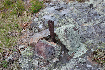
We had spent a day last fall exploring along the Schooner Head Road, wandering down narrow dirt roads that quickly turned into rough paths, one such road led us to a place we named the Schooner Head Road Monitoring site, clearly in Acadia National Park and the monitoring operation there run by the National Park Service. Different tree's were marked with metal tags, some marked with paint, some had a strange goop on them, and here and Clearly we had stumbled into a unique area in the park, and for anyone venturing into that area I would caution not to disturb whatever it is the National Park Service is doing in there. In fact, I would not even do a blog on this site if it wasn't for the historic value of that area. As your making your way in through the woods, you come upon this section of dirt road that passes along the edge of a drop off, and the entire side of the drop off is a sheer wall of granite blocks which support one side of the road. Just beyond this is an intersection, just up to the right is the tree and ground monitoring area. I don't know what the strange goop on the side of some of the trees is, but clearly it is not pitch and I would avoid touching it. Again, the right hand side of the road here is well built up with granite blocks, but to a much lesser extent than the sheer wall of granite blocks you passed earlier. Once you exit the woods you come to a most unusual round area of open granite with large metal tie down stakes, much like you would expect to see around a tower of some sort to help hold it in place. I have not a clue as to what was once there, but the old iron bars sticking up out of the ground suggest something large was once located in this open granite circle. A little more exploring in the general area and we discovered a fast running stream of water passing right up through a deep gorge which ran off into the woods, the gorge was extremely steep, enough so that we could not find no way to get down into it and it did not seem like a good idea trying to follow it through the woods, as a fall down into it would result in serious injury.
We returned back to the worn trail and followed it until it brought us back to the intersection, we did spot a few pieces of metal sticking up out of the ground, which appeared to be part of the monitoring going on there.
The dirt road is blocked off by a few large granite blocks, and the GPS to the start of the road is listed below.
N44 36.232 W068 18.859
 |
| OLD DIRT ROAD - SCHOONER HEAD ROAD ACADIA NATIONAL PARK |
 |
| BUILT UP SIDE OF DIRT ROAD SCHOONER HEAD ROAD ACADIA NATIONAL PARK |
 |
| OLD DIRT ROAD - SCHOONER HEAD ROAD ACADIA NATIONAL PARK |
 |
| IRON TIE DOWN BAR - AT OPEN GRANITE CIRCLE SCHOONER HEAD DIRT ROAD ACADIA NATIONAL PARK |
 |
| MONITORING SITE - OLD DIRT ROAD SCHOONER HEAD ROAD - ACADIA NATIONAL PARK |
 |
| MONITORING SITE - SCHOONER HEAD ROAD ACADIA NATIONAL PARK |
 |
| MONITORING SITE - STRANGE GOOP ON TREE ACADIA NATIONAL PARK |
No comments:
Post a Comment
Note: Only a member of this blog may post a comment.