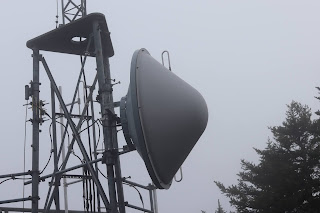
As you driving along the Cadillac Summit Road, and approaching the summit, you come to a dirt road on the right with a strange post with the large numbers, 11, 12, 13 on the post, located a locked gate. If you walk a short ways up that dirt road, the one to the left, (the one to the right is a dead end) you come to a government instillation with antenna towers and various buildings located in a well fenced in and locked area. The reason I even stumbled upon this location was because the Green Mountain Railway route passed close to this area. I did come across another find, but I will not post about it, as I am pretty certain the Park Service would not like it as it is not fenced in.
Abandoned Trails Of Acadia national Park is a site dedicated to covering lost and abandoned hiking trails in Acadia. We cover old ghost trails as well as phantom trails, offering visitors to our site more trail listings, more trail details and more maps than any other online site. We regularly update the site and add newly discovered information as it becomes available.
Wednesday, September 9, 2020
CADILLAC MOUNTAIN GOVERNMENT INSTALLATION
In the photo above you see there are not one, but two roads behind the closed gate, the second road, marked narrow paved road, runs down through the woods a ways before suddenly ending, and where the road ends is a well worn path continuing onward down the mountain side and has the feel of being an old abandoned hiking trail, the further we followed it the ground seemed to get rougher - not sure where it led as we began losing out light. At one point an official trail does cross this road as well. the path at the end of the road is not part of that trail.
To the right of the old paved road is a shallow ravine filled with huge sections of granite, some had the tell tale cut marks on them.
Subscribe to:
Post Comments (Atom)


No comments:
Post a Comment
Note: Only a member of this blog may post a comment.