Tuesday, May 30, 2017

KEBO MOUNTAIN GRANITE MINING SITE


While hiking the Strath Eden Trail nearly 20 years ago, I passed an area along the official trail that looked like it was an unmarked trail, so today we went back to that area in hopes we would be able to find it again.  Once again we forgot the bug spray and the bugs were relentless, but we did find what we set out to find, an unmarked trail.
Strath Eden Trail
Acadia National Park

Okay, as we began hiking along it we soon realized this was no trail, this was in fact an old abandoned road.  You could still see the itre groves, and the entire left hand side of the old road was well built up and lined with rocks - see photos.  But no sooner had we begun to wonder where the road went to, that it suddenly came to an end.  The area where it ended had towering walls of granite that were smooth and perfectly flat, and clearly appeared to be an old granite mining site.
And on a large rock was a pile of rusting metal parts, a few of the parts seemed to clearly have come off of some sort of truck or machine.  Check out the photos and see what you think.
Strath Eden Trail
Acadia National Park

So we poked around the entire area searching for more signs of anything that might be there and found nothing.  So we decided to make our way up the mountain side oven an open area and soon came to the woods, and there amid piles of what appeared to be cut granite, one large piece proved this area was once a granite mining area.  It had the tell tale grooves evenly spaced along one side.
Drainage Ditch Along Strath Eden Trail  Where Old Road Leads To Mining Area
Acadia National Park
 Here the drainage ditch veers right away from the official trail, this is where the abandoned road begins.

So to find the general area of tall walls of granite and rusting metal parts, hike along the Stratheden Trail and pay attention to the drainage ditch on the right hand side of the trail not far into the hike.  At one point a long section of the ditch makes a sudden right hand turn and actually begins to go up the abandoned road.  And you don't have to go up the old road very far before you see how one side of the road is lined with large rocks.
Old Mining Road Off Strath Eden Trail
Acadia National Park
 Here you can see how rocks line one side of the old road.


The hardest part of finding this location is in first finding the Stratheden Trail, which is very easy to miss.  Begin by driving or biking along the one way section of the Park Loop Road.  You will soon pass the pull over for the Cadillac North Ridge Trail.  The road than goes down hill, and crosses a large stone bridge - the start of the Gorge Trail is below the bridge.
Pile of rusting Metal Near Granite Mining Area
Acadia National Park

Metal Along Old Road Off Of Strath Eden Trail
Acadia National Park

Continue down the road until you come to a long cruve, half way through the long curve is the Kebo Mountain Trail Head.  As soon as you exit the long curve, slow and look for a very tiny pull over on the left and side of the road, that is where the Stratheden Trail begins.  The pull over is large enough for one, maybe two cars at the most.
Cut Granite in Woods Off Of Old Road Along Strath Eden Trail
Acadia National Park
The GPS numbers for the start of the Granite mining road, which is mentioned in  Path Finders, is Latitude 44 22' 7" N and Longitude 68 12' 53" W.


KEBO MOUNTAIN GRANITE SITE
ACADIA NATIONAL PARK


MAP OF KEBO MOUNTAIN - ACADIA NATIONAL PARK

Saturday, May 27, 2017

ABANDONED SEAL COVE SHIP WRECK


MYSTERIOUS SHIP WRECK OF SEAL COVE

It is a mystery because no one seems to know much about the ship wreck or how the large ship came to be where its remains are located today.  An older gentleman recalls playing on the wreck when he was a young boy. 
In most pieces I have found on this ship wreck, the Park Service has stated they wanted the ship wreck's location kept a secret, however, documents found online tell the location of the wreck.  There are also a number of photos of the ship's remains as well as photos of what the ship might of looked like.

The ship is said to have been a large vessel, the kind most often used to carry passengers.  
On a video showing Park Rangers at the site, it is said that the vessel entered a narow cove and either crashed or came to rest on the far side of the cove in an area that is mud at low tide.  So to access the crash site one would have to arrive in the area at low tide.  It's location as described below appears in a free online PDF on the ship wreckage;
"The shipwreck is located on the north shore
of  the  eastern  end  of  Seal  Cove,  on  Mount 
Desert  Island,  in  the  intertidal  zone  (
fig
.  5). 

SEA COVE SHIP WRECK SITE
MOUNT DESERT ISLAND

East  of  the  main  part  of  the  cove,  the  site  is 
next  to  a  narrow  channel  that  is  nearly  dry  at 
low  tide,  limiting  the  draft  of  vessels  able  to 
enter. The site was reported by local informants
in  2006  and  listed  with  the  Maine  Historic 
Archaeological  Sites  Inventory  in  July  2007  by 
Anthony Booth of Independent Archaeological
Consulting  (Maine  Historic  Preservation 
Commission 2007: 1–2; Price 2007)."
On a video showing Park Rangers at the site, it is said that the vessel entered a narow harbor and either crashed or came to rest on the far side of the harbor in an area that is mud at low tide.

SEAL COVE SHIP WRECK SITE
Mount Desert Island


 PDF OF SEAL COVE SHIP WRECK PROJECT

SEAL COVE SHIPWRECK PROJECT WEBSITE 

THE BRIDGES OF SEAL COVE


Thursday, May 4, 2017

BAR ISLAND GLACIAL TRAIL


ACADIA NATIONAL PARK

BAR ISLAND GLACIAL TRAIL - ACADIA NATIONAL PARK
Bar Island, for a very long time, was an island divided, with Acadia National Park owning one half of the island and Jack Perkins and his wife owning the other half.  Mr. Perkins name should sound similar to any of you who watch any amount of public broadcasting TV, as it is his voice behind many of PBS documentaries.  He once said that life on Bar Island revolved around the ebb and flow of the tide, with things like shopping, car repairs and hair appointments having to be made in such a way as to fall with the low tide mark.

BAR ISLAND GLACIAL TRAIL - ACADIA NATIONAL PARK
The low tide mark is important even if you never lived on Bar Island, for even a day visit on foot has to be done two hours before low tide to within two hours after the low tide mark, lost sight of time and you very well could be trapped on the island until the next low tide, which occurs twice a day.  It use to be the town or the National Park Service would come get you if you had the misfortune of getting stranded there, but in recent years the town has placed the business of retrieving stranded tourists in the hands of a local business, and it will now cost you $150.00 for a return trip back to town.  Oddly, when the town put up large signs spelling out this new policy, they some how managed to place one of the large bolts holding the sign right through the 1 in $150.00, so it appears the taxi fee is $50, funny how that happened.  My advice, do not call the town or the harbor master if you get stranded on Bar Island, instead contact the National Park Service, which I believe will still come and get you for free, but there may be some waiting time involved.

Glacial Rock, Bar Island, Acadia National Park
The Bar Island Glacial Trail is easy to locate if you follow the direction given here.  Walk over to Bar Island at low tide, There is an information sign where a dirt road begins, passing uphill through the tree's.  Just ahead is a sharp right hand turn, look behind some small tree's at that sharp turn in the road, on the left hand side, same side as the water, and the worn trail is plain to see - but not plain to see i9f you fail to look behind the small tree's.  The path quickly makes its way to a cliff overlooking a rocky beach, where you can get some nice photos along the cliff, and than the path turns away from the cliff and enters the woods.  The path is short and well worn, follow it through the woods where it comes to a high cliff at the back side of the island, to the left in the tree's is one huge glacial Boulder, and to the right, perched on the side of the cliff is an even larger glacier boulder, it is this second boulder people go to and have their photo taken by it.  To the left of the cliff is a path leading out to an open granite area along with a few places where you can make your way down to the stone beach area.  When two or more cruise ships arrive at Bar Harbor on the same day, the town has one or two of them anchor in the water back here and it gets you really close to those huge ships.

BAR ISLAND - ACADIA NATIONAL PARK


Back in the day, before there was a National Park here, there was a few farms on Bar Island, and at one time the town hired an engineer to draw up plans for a stone bridge to run from Bridge Street to Bar Island following the sand bar.  The bridge was to be constructed of stones, and have several arches where passing boats at high tide could pass under the bridge.  The plan also called for a road to run around the island in a loop, and as the town council at the time said, "It will offer locals and guests to the island even grander views than that found along the Shore Path."  Interestingly enough, the plans were approved as was the funds to construct the large stone bridge, so what became of the Bridge?  Clearly it was never built, but why remains a mystery, considering the plans and money was approved by the town council.
And it was not the last bridge to be proposed for Bar Island, years down the road the town was to construct a ferry terminal, but where to put it was a subject for debate.  In the end, it came down to two locations, the site where the Ferry Terminal is located at today, and Bar Island.


When three cruise ships come to Bar Harbor, one usually anchors to the back side of Bar Island, and you get get a very closeup view of it from this trail.

Start of dirt road on Bar Island;
latitude       N44.3970947
longitude     W068.2109980

As road turns right, look for path to left
latitude       N44.3976598
longitude     W068.2114336

Huge Glacial Boulders
latitude       N44.3991963
longitude     W068.2122823


  The Ferry Terminal plans for Bar Island called for building a bridge from West Street to Bar Island, but this bridge would not follow the sand bar, instead this bridge would be constructed closer to town, across from lower Rodick Street.  The plan called for bringing in truckloads of fill and creating a 300 car parking area on one side of the island, and as crazy as it might sound today, many back than favored the Bar Island plan.  The town council made a request for the planning board to look into which site would best benefit the town long term, but as more and more time went by, the town was up against a deadline with Canada, and it was decided the current Ferry Terminal location would have to do.  The planning board did finally produce their study, but it came in too late - so exactly what site did they deem as the most appropriate  site that would best benefit the town of Bar Harbor long term?  Bar Island was their choice, the moral being, when up against a deadline, get your report in on time.


Bar Harbor view from Bar Island - Acadia National Park


Deer in Deer Field, Bar Island, Acadia National Park
Bar Island is considered a high sensitivity area due to the vessels that have wrecked along its shores over time.  During  the early twentieth-century records show a boat, a sloop, and a catboat wrecked along the shores of Bar Island, than known as Rodick Island.  In 1908 a gasoline boat owned by George young and L. Stewart as well as a sloop owned by Milton Rodick crashed along its shores during a heavy gale, one ending up totally distroyed.  In 1911, during the same gales that wrecked the Tay on Sand Beach, the catboat Flirt wrecked on Bar Island.

Tuesday, May 2, 2017

ABANDONED DUCK BROOK TRAIL


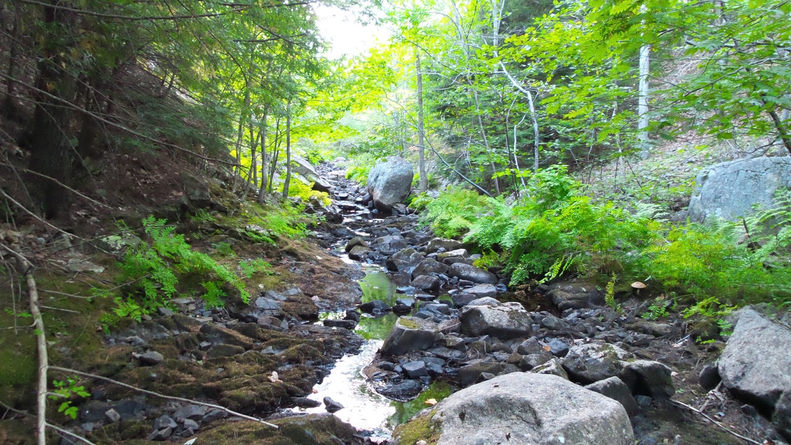
The Duck Brook Trail, or path as they were once called, dates back to the 1800's.  If you have ever hiked up the length of Duck Brook, as I have a number of times, than you are aware of just how rough some sections of the hike can be today.  In fact attempting to walk along either side of the brook the entire distance can be a slow process and in many sections nearly impassible, but that was not always the case.  Old maps do not paint an accurate picture of the Duck Brook Path as old maps show the path running along one entire side of the brook.  In reality,the path criss crossed the brook in several places by means of wooden rustic foot bridges, many with roofs over them and wide enough to accompany wooden benches where hikers could sit and relax above the rushing waters of the brook below them.  Over time, the land exchanged hands, the foot bridges fell into disrepair and were eventfully taken down.  And as years passed, dams were built along the brook at different places and later removed, replaced with beaver dams, which helped raise the level of the water along the old path.  A system of stepping stones had been placed along the side of the brook, but today those stepping stones are below the water level.
It is true, if you are able to follow the difficult terrain, you will come across small stretches of the old Duck Brook Path along the way, still well worn and in good shape in sections, and if your lucky enough to have access to the brook during a long dry spell, as we did, a hike right up the center of the brook is by far the easiest way to traverse the terrain.


Duck Brook Trail - Acadia National Park


Though I have never been able to prove it, it is my thought that back in the day, a rustic foot bridge was used to connect the Gurnee Trail with the Duck Brook Trail, as both paths began by the bridge along Eden Street.

Duck Brook Trail - over grown and in rough shape

Here is a short piece Martin's Guidebook wrote on the Duck brook Path;
"The real attraction of the walk is the ramble along the brook, sometimes on one side, sometimes on the other, and not seldom in the bed of the brook itself.  The gentleman to whom the estate of the brook now belongs  has constructed a path with rustic seats and bridges for quite a distance, so that both the waterfalls may be reached with no great difficulty.  Beyond however, the walk becomes a scramble, for which one must have not only stout boots but well trained boots."  This piece was found in the book Pathmakers.


view of the second arch from down by the brook
Pathmakers also says that in 1890 Duck Brook Path went from Eden Street all the way to the Eagle Lake Road, which means it must of crossed some really rough sections of ground.

start of trail moving left, below bridge

It is hard to imagine the trail continued through this location, as there is really no place to walk along, and further up along the brook, as you make your way toward the Duck Brook Bridge by the Carrage Roads, you encounter Duck Brook Falls where white water racings down into the brook below.    You don't have to see it, one can hear its roar from the Duck Brook Road up above the Brook. 
Duck Brook - Acadia National Park
As far as arriving at Duck brook, there is three ways to do so on this end of the brook.  The first is to walk down the banking to the brook from Eden Street and follow the brook from there.  The second approach is by way of the towering triple arch bridge you come to shortly after leaving the visitors Center.  Park and find a way down below the bridge you feel comfortable with.  The waters of Duck Brook pass beneath the center arch and so does the old trail, though for a stretch you need to poke along through brush and woods before arriving at worn sections of the trail by the waters edge.  Even the waters of the brook beneath the bridge are something to behold. 
The other approach is from near the start of the Water Pipe Trail, there are a few places not far down the path where you can safely get down below to the edge of the brook. 

Here Witch Hole Brook joins Duck Brook

So why is the path in the area  below the stone bridge so destroyed?  The answer is a pretty simple one, during the years that the Duck Brook Path was popular, there was no National Park and no bridge.  After the park came into being, the bridge was built, and a large section of the trail was destroyed in and around the area of the bridge.
I found it interesting when I read in Pathmakers that in 1923 that two new flights of steps had been built from Duck Brook to Witch Hole Pond trail, not sure where those were located.  It goes on to say that 68 stepping stones had been added by the brook.
Abandoned Duck Brook Trail


Duck Brook - Acadia National Park


Duck Brook - Acadia National Park

THE FALLS - DUCK BROOK - ACADIA NATIONAL PARK
Hard to believe, but this photo was taken from the center of the falls where fast moving white water is usually found, check out the video further up and you will see how powerful the water usually is blasting through here.  To our surprise, due to a long stretch of very dry weather, we got to walk right up the center of Duck Brook, for the first time seeing sections of the old path that have lay hidden for many long years.
DUCK BROOK - ACADIA NATIONAL PARK
This is just behind the falls, at almost any other time you could not cross this area of the brook, it was just amazing to be able to walk up the center of this.
RUINED STAIRWAY - DUCK BROOK - ACADIA NATIONAL PARK
The photo above was first marked as one of the two stone stairways that once led from the brook, but after reading an old article, it stated the area along the brook where many blocks of granite line the hillside is the spot where the Bar Harbor Water Company Flume crossed the brook, the blocks once being part of the support system for the flume.


STEPPING STONES - DUCK BROOK - ACADIA NATIONAL PARK
In the above photo we came upon a rare but beautiful find, a stretch of old stepping stones which once helped people hike along the edge of the brook.  Today, due to the waters of the brook being somewhat higher, these stepping stones remain under water and unseen, we found a number of places like this one along the way.  It is worth noting here that even when the waters of the brook were not as high, and even with the rustic foot bridges, at times the water level would rise and this main path was difficult to follow until the water levels fell, so a second Duck Brook Path was built higher up the banking.  I believe the first water pipes that were laid followed that second path, and later became named the water pipe path.
One year we found a six pack of beer floating in the waters of Duck Brook, but a bag of rocks?  It made no sense why someone would place a bag of rocks in the center of the brook, that is, it didn't make sense until we saw the note inside the bag - which could not be seen before we picked the bag up.  It says this belongs to the National Park and contains a water level monitor in it, and sure enough we saw some tiny device in with the rocks.  It also said not to remove the bag, so we placed the bag back into the small pool of water as we had found it.
DUCK BROOK TRAIL - ACADIA NATIONAL PARK
In the above photo, as we got closer to the Duck Brook Bridge by the Carriage Roads, we began to come across a few sections of built up trail bed, it is clear to see that back in the day, this was a pretty nice trail at one time.

A crazy scene from War of the World?  I have not a clue what these are or why they were bolted to a large rock by the brook, they do not appear to be very old and clearly they are used by the Park Service in one way or another.
DUCK BROOK APPROACHING DUCK BROOK BRIDGE CY CARRIAGE ROADS


The old Bar Harbor Water Pipe runs along the bank of the brook here. This is a section of the first water pipe, made of cast iron.
In this photo you can see a few of those 68 granite stepping stones the park had placed along the brook many years ago.  Each block has cut marks, and we must of located close to 45 of the 68 blocks.  The perfectly square granite blocks can be found all along the brook.
DUCK BROOK BRIDGE - ACADIA NATIONAL PARK

DUCK BROOK BRIDGE
My son trying to figure out where all the water disappeared to.......
DUCK BROOK ARCHES - ACADIA NATIONAL PARK
ABANDONED TRAILS - DUCK BROOK BRIDGE - ACADIA NATIONAL PARK
This was an amazing hike along a stretch of the brook you normally can't get access to. 

WHERE FLUME CROSSED DUCK BROOK
Acadia National Park
From here the Bar Harbor Water Company Flume would of crossed over the brook and ran along one side of Great Hill to a granite reservoir, with the final  reservoir being located on Scott's Hill or what is today called Schoolhouse Hill.  I have a blog on this explaining how I discovered the location of Scott's Hill, so why has no one ever been able to locate the remains of that last reservoir?  The answer was found in an old newspaper, while the reservoir by Great Hill was of granite, the one on Scott's Hill was constructed of wood.

BLOG ON SCOTT'S HILL